Canyonlands Visitor Centers
Island in the Sky Visitor Center
Island in the Sky Visitor Center is open daily from spring through fall from 9 a.m. to 4 p.m., with extended hours in the summer (4:30 p.m.).The visitor center is closed on Thanksgiving Day and from late December through February. Backcountry permits are available up to one hour before closing.
Getting there from Moab: Drive north on U.S. 191 for 10 miles to S.R. 313. Further north, starting on I-70, head south 22 miles to S.R. 313. Once on SR 313, head southwest 25 miles to the Island in the Sky entrance station.
Needles Visitor Center
Needles Visitor Center is open daily from spring through fall, from at least 8:30 a.m. to 4 p.m. It closes on Thanksgiving Day and from early December through February.Getting there from Moab:To get to the Needles District from Moab, take U.S. 191 south for 40 miles and turn right (west) onto S.R. 211. Follow the paved road 35 miles to the Needles District entrance station. Watch for the Canyonlands National Park sign — Needles Overlook Road appears a few miles before the correct junction and does not lead to the park.
From Monticello: Drive north 14 miles on U.S. 191 and turn west onto S.R. 211
Maze District: Hans Flats Ranger Station
The Maze is the most remote district in Canyonlands, accessible only by unpaved roads. The Hans Flat Ranger Station is open from 8 a.m. to 2 p.m. and is located 2.5 1/2 hours from from Green River, Utah.
Getting there: From I-70, take Utah Highway 24 south for 24 miles. Turn left just past the Goblin Valley State Park turnoff and follow the two-wheel-drive dirt road 46 miles southeast to the ranger station.
Beyond the Three Districts
Canyonlands also includes two additional areas worth exploring: the Horseshoe Canyon Unit, a detached section northwest of the Maze that features prehistoric pictographs in the Great Gallery; and the River District, which includes stretches of the Green River and Colorado River.

Photo: Courtesy of Angela Houghton
Explore Canyonlands Thoughtfully
Give yourself a few extra days to explore the region around Canyonlands National Park. A drive down Main Street in nearby Moab solidifies the town's reputation as a major hub for outdoor recreation. You'll find it is bustling with mountain bikers, river rafters, climbers, canyoneerers, hikers and off-roaders who have come to play (Read: Best Time to Visit Moab). The Complete Arches Trip itinerary will give you a proper lay of the surrounding area.
Visiting neighboring towns like Moab, Green River or Monticello provides a great opportunity to support local businesses. These unique gateway communities offer lodging, dining, shops and guided outfitters to help make the most of your visit to the area.
Fees and Permits
Responsible Travel Tips
-
Check the Weather
Be sure to read the weather forecast and understand how the climate and conditions will impact your day’s outing and be aware of your own limits. Pack accordingly and be sure to bring enough water, food, proper clothing and sun protection.
-
Get the Latest Information
Check the current regulations and suggested guidelines for the places you intend to visit. For the latest information, visitors may follow Canyonlands National Park on Twitter and Facebook or check nps.gov for the latest park alerts and conditions.
-
Make a Plan
Create a trip plan and make sure someone knows where you are going and when you will return. Don’t expect cell phone service to work, having a printed map is always helpful. Be aware of potential hazards, including wildlife, lightning, flash floods and extreme heat. Assess your abilities, goals and skills and make sure your planned activities are a good match. Reach out to a park ranger if you’re unsure.
How far is Canyonlands from other National Parks?
Canyonlands sits at the heart of Utah's Mighty 5, making it one of the best home bases for a southern Utah road trip. Arches is the closest neighbor, less than 30 miles away and under an hour by car. Capitol Reef is about 155 miles west, roughly a 2.5-hour drive. Bryce Canyon sits around 285 miles out at about 4.5 hours, and Zion is the farthest leg at roughly 340 miles and 5 hours.
What is the drive time from Canyonlands to Arches?
Arches National Park is about 30 miles and 35 minutes from Canyonlands’ Island in the Sky entrance, making them the easiest parks to pair in a single day. Base yourself in nearby Moab and you're set.
What is the drive time from Canyonlands to Zion and Bryce Canyon?
Bryce Canyon is about 285 miles from Canyonlands, roughly a 4.5-hour drive. Zion is the farthest of the Mighty 5 at around 340 miles, putting it about 5 hours away. Make it a triple stop and visit Bryce Canyon on the way to Zion. Bryce Canyon is just 80 miles and about 1.5 hours from Zion, making a Canyonlands-to-Bryce-to-Zion route one of the most rewarding road trips in the Southwest.
What is the drive time from Canyonlands to Capitol Reef?
Capitol Reef is about 147 miles and 2.5 hours from Island in the Sky, an easy and scenic half-day drive. Fill up on gas before you leave Moab, as services are limited through the Hanksville stretch.
Visit With Respect
The red rock desert is a fragile ecosystem, and visitors should take special care to protect it. Practice Leave No Trace principles to ensure that all parts of the park are left as nature intended.
Pack out everything you bring with you, including food wrappers, tissues and even crumbs. Canyonlands requires visitors to pack out solid human waste, toilet paper and hygiene items. (Read: How to Poop in the Outdoors)
Stay on existing trails and do not travel off course or “bust the crust.” A single footstep can cause damage that lasts for decades. Rock cairns, or rock piles, are trail markers. Do not disturb them or add new ones, as they could mislead other hikers.
Treat the arches and other geologic features with respect, both to protect them and yourself. Walking, climbing and scrambling on arches — even for a quick photo — is not permitted.
Leave rocks, plants, animals and natural objects as you found them. Never leave marks or scratches on rocks or other surfaces and admire artifacts and natural features from a distance without touching or disturbing. Tree carvings, rock etchings and spray painting are forms of vandalism and graffiti, which are illegal on public lands.
Respect the wildlife that make Canyonlands National Park their home. Keep your distance, and if an animal changes its behavior due to your presence, you are too close. Secure your food so animals cannot access it, and never feed wildlife.
Camp only in designated areas on durable surfaces and follow all campfire rules and regulations.
Leave drones and pets at home. The use of off-highway vehicles (ATVs, OHV, UTVs, etc.) is also not allowed in Canyonlands National Park.
Be courteous to other visitors by minimizing noise, yielding to others on trails and respecting trail and transportation signage.
Show consideration for other visitors, and be a mindful photographer. Canyonlands is an internationally certified Dark Sky Park, making it a prime location for night photography or stargazing. Do note that using artificial light sources to illuminate park features for photography is not permitted.
"Visit Canyonlands in a considerate way to ensure this wild place stays a spot that future generations can continue to enjoy."
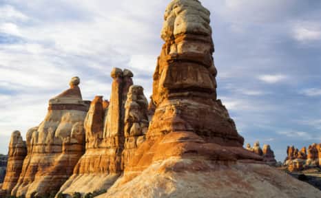
The Needles district of Canyonlands National Park
Canyonland National Park contains three districts — Island in the Sky (most popular), Needles and Maze (most remote).
When traveling with a group in the outdoors, it's important to understand the limitations of each individual in your party.
Photo: Rosie Serago
Take Care of Yourself in the Desert
You can’t enjoy the splendor of Canyonlands sufficiently and preserve this treasured place if you’re not first taking care of yourself and those in your group. Watch where you step, know your physical limits and pack all your essentials, from first aid or medical supplies to proper clothing and enough water and food.
Prepare for the Heat
During the hottest parts of the day in the peak of summer, temperatures can spike over 100°F. Avoid exertion or overheating during the peak temperatures of the day. Consider hiking in the cool of the mornings and evenings. There is very little shade on most trails within the park. Protect yourself with sunscreen, sunglasses, a hat and protective clothing.
Stay Hydrated
Dehydration is one of the biggest risks in Canyonlands' desert environment. Bring at least one gallon of water per person per day and drink before you get thirsty. Natural water sources may be seasonal or dry entirely, and untreated can contain harmful or toxic microbes that can impact human and pet health. Know where drinking water is available before you hit the trail.
Pack Enough Food
Bring enough food and snacks for your group and for the outing you have planned and be aware of where food is served within or outside the park. Remember to pack out what you brought in and dispose of all trash properly.

The Complete Canyonlands Trip
The Canyonlands Region of Utah combines the best of the Moab area's easy proximity to Arches National Park and Canyonlands National Park's most accessible district with some of the United State's most remote and culturally significant landscapes.
Highlights
- Canyonlands National Park
- Dead Horse Point State Park
- Bears Ears National Monument
- Natural Bridges National Monument
- Monument Valley Navajo Tribal Park