Location: North-central Utah, just west of Salt Lake City.
Overview: A 120-mile basin and range drive that reveals elements of Utah’s mining, Pony Express, and Mormon history as well as the dramatic alpine terrain of the Deseret Peaks Wilderness Area and the forbidding desert wilderness of the Great Basin. This drive is a very good (and relatively easy) introduction to the Great Basin region as a day excursion from Salt Lake.
Special Attractions: Stagecoach Inn/ Camp Floyd, Mercur and Ophir mining camps, Deseret Peak Wilderness Area, Stansbury Mountains, Skull Valley, Great Basin views, Iosepa.
Travel Season: Generally year-round, with much less to do in winter. Both backways are closed in winter, while drifting snow can sometimes be a problem throughout this drive.
GPS of Start: 40.259969, -112.096136 (Fairfield)
GPS of Mid-Points: 40.551096, -112.298113 (Tooele); 40.220293, -112.742818 (Dugway)
GPS of End: 40.744014, -112.653451 (I-80/Rowley Junction)
Drive Route Numbers & Names: Highways 73, 36, 112, and 199; Middle Canyon Scenic Backway; South Willow Canyon Scenic Backway.
Camping: Six national forest campgrounds on South Willow Creek Road, one BLM campground at Johnson Pass, primitive camping along some segments of the drive.
Services: All services at Tooele; most services at Grantsville; gas and food at Ophir and Stockton.
Nearby Attractions: Pony Express Trail Scenic Backway, Clipper Peak Overview, Great Basin drives, Great Salt Lake, Wendover, Bonneville Salt Flats.
Visit Utah Itineraries: Grand Adventure in the Great Basin & West Desert Ramble and the Pony Express
The Road Trip
There are several ways to begin and end this drive. The drive organized here, a full-day excursion from the Salt Lake Valley, is designed to take advantage of the morning light on the east faces of Deseret Wilderness Area peaks and afternoon/ evening light on its west side. Shorter versions of this drive might start at either Tooele or Grantsville (accessed quickly via I-80 from Salt Lake) or might remain to the east of Deseret Peak with a possible return to Salt Lake over Middle Canyon Road.
All of the valley roads, and those up to Mercur and Ophir, are paved and suitable for all vehicles. Parts of the Middle Canyon and South Willow roads are unpaved and unsuitable for trailers, larger RVs, or low-slung cars. With few services along this route, it’s a good idea to bring lots of water and possibly a backcountry water filter to take advantage of remote springs. The best source of information about unpaved roads, camping, and recreation anywhere in Utah’s Great Basin is the BLM field office on Salt Lake City’s west side.
On the Pony Express Trail
The drive begins at Fairfield, reached easily from the second Lehi/Highway 73 exit on I-15, a short drive south of Salt Lake City. As you drive west on Highway 73, you are following the old Overland Stage and Pony Express route and are at the start of what was generally considered one of the most dangerous and difficult sections of the long trail across the desert.
In 1858 General Albert Johnston arrived here with 3,500 federal troops out of government fears over a Mormon insurrection. Johnston established Camp Floyd, which was, at the time, the nation’s largest single concentration of soldiers. The town of Fairfield grew prosperous on business generated by the troops, and it reportedly had 17 saloons. The combined population of town and camp was more than 7,000, making this the second largest community in the territory. The camp disbanded, and the town depopulated in 1861 on the outbreak of Civil War hostilities back east.
The Central Overland Stage and the Pony Express had stops here, where John Carson built his popular inn. This inn has been restored as the centerpiece of a low-key historic site—it’s open 9 a.m. to 5 p.m. Monday through Saturday. It makes a nice picnic spot if you get a late start.
Continue west on Highway 73 to where a good paved road comes in on the left, well marked as the Pony Express Trail Scenic Backway. Take this left to continue on the fascinating Pony Express trail. This backway runs through Faust, over Lookout Summit, to Simpson Springs and Fish Springs, then across Antelope Valley into Nevada. The first 15 miles or so, to Faust, are paved, followed by well maintained gravel suitable for all vehicles in dry conditions.
The drive traces the Pony Express trail across western Utah, one of the roughest stretches on its entire 1,900-mile route. Fish Springs is a true desert oasis, an 18,000-acre marshland rich in waterfowl and the nation’s most remote National Wildlife Refuge. The Pony Express trail is a much-recommended side trip if you have the time (and lots of water and a full tank of gas—there are no services until Ibapah). The BLM distributes a brochure describing historic sites en route, available at BLM offices in Salt Lake; it may also be found in Lehi or Fairfield.
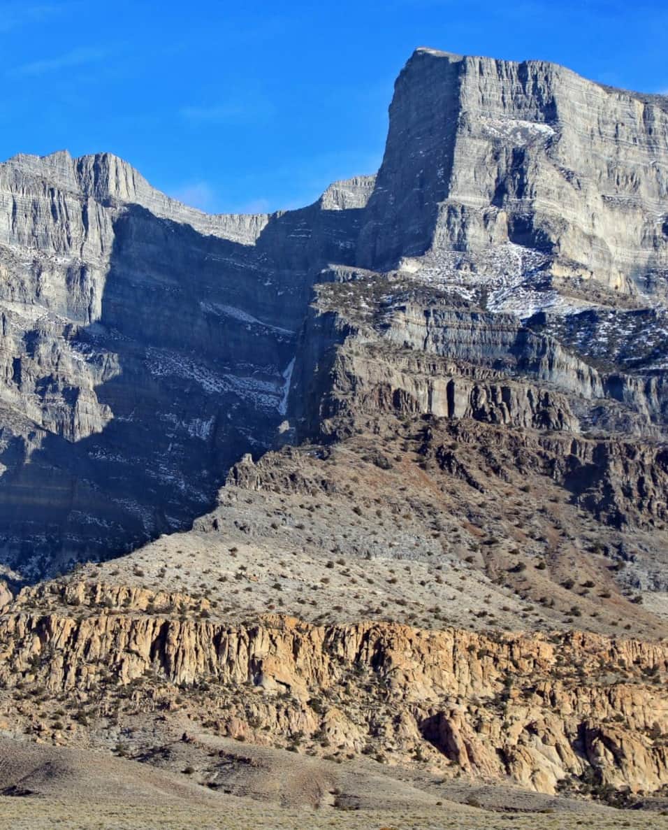
Highway 73, west of Fairfield and south of Mercur, gives a really good taste of Great Basin driving and a real sense of the immense desert expanses out here. The Oquirrh Mountains form the eastern boundary of Rush Valley, with the Stansbury and Onaqui Mountains on the west. Back and to the left is the rough, empty terrain crossed by the Pony Express; it is still essentially unchanged today. In early light, the east face of Deseret Peak is especially dramatic from the east side of the valley.
Highway 73 curves to the north just past the Pony Express turnoff, entering the well-watered Rush and Tooele Valleys.
Mining History
About 9 miles from the Pony Express turnoff is the turn on the right for Barrick/ Mercur Gold Mine. Once Utah’s leading producer of gold, the strip-mining operation has been replaced by a new processing plant, and the area is being restored.
After booms and busts, the astronomical rise in gold prices during the 1970s created the latest rebirth of Mercur, “the town that can’t stay dead.” Displays at the mining museum in the Deseret Peak Complex on Highway 112 in Tooele give some sense of both Mercur’s history and of the nature of modern gold processing. The museum’s hours are sporadic, but you can always get someone at the complex’s information booth to open it for you.
Just north of the Mercur road you get really excellent views of the Deseret Chemical Depot, and you may wonder, “Gee, what sort of nastiness goes on down there?” This is, indeed, a chemical weapons storage and incineration depot, which makes the prospect of buying a lot with a view above this valley much less attractive. It is a little more than 4 miles to the road to Ophir, on the right, a quaint combination of parks, old mining cabins, and other remnants of a bygone era. The historic district and surrounding hillsides are a great place for history buffs to explore; keep in mind much of those are private land.
Just north of the Ophir turnoff you will see Rush Lake. Like the Great Salt Lake, this lake has no surface outflow, draining solely by underground seepage and evaporation. In wet years, Rush Lake is very popular with sail boarders (in dry years, it barely exists at all). Highway 73 ends 4.5 miles north of the Ophir road at the intersection with Highway 36. A little more than 2.5 miles north of here, note on the left the marker topped with a red metallic pennant (nicely perforated with bullet holes). An early military camp was established here in 1854 by the first detachment of soldiers to enter the Rocky Mountain region. Access to Rush Lake is through tiny Stockton (with gas station and old-timey cafe), 4.5 miles north of the Highway 73/Highway 36 intersection.
Beckoning Backways
It is 10 miles from here to Tooele, a proper metropolis with its own sprawling suburbs. The best suggestions for the source of the name Tooele is that it is a corrupt form of the name of an early Native American chief, Tuilla, or of the Spanish/Aztec word tule, for bullrush.
Tooele is also the starting point for Middle Canyon Scenic Backway, a nice unpaved diversion for those in high-clearance vehicles. Drive north on Main Street to Vine Street, the main east–west street in the heart of Tooele. (There may or may not be a sign for Middle Canyon Scenic Backway, so just watch for Vine Street.) Just as you turn right (east) on Vine, note the very attractive stone building on the left, built in 1867 as the Tooele County Courthouse, now the museum of the DUP. A few blocks farther along is the very interesting Tooele County Museum. Past the prominent Catholic Church on the right, the road winds up, out of town, and into wooded Middle Canyon.
There are nice picnic spots on both sides of the road. At about mile 5.5 the canyon opens up a bit, and this becomes an attractive mountain drive, still on good paved road. At mile 6.7 the hard surface ends; do not bring trailers or RVs beyond this point. The road beyond here is often rough, with steep switchbacks, so inquire in Tooele (or at the BLM office in Salt Lake City, before you go) about conditions. At mile 8.2 you reach the high point on this main road, and it drops down on the other side into the Salt Lake Valley (making this a possible alternative return to Salt Lake City). On the left is a rough, steep dirt road that goes up another 2.5 miles to one of the most spectacular views in all of Utah. From the Clipper Peak viewpoint, the massive Bingham Copper Pit is right below, and across the valley is the Wasatch Front, with Salt Lake at its feet. From here you can see all the way north to Ogden and south to Provo and Mount Nebo.
On the east (Salt Lake) side of the pass, the gravel quickly becomes pavement descending Butterfield Canyon through forests (and about 7,553 Kennecott Copper Co. No Trespassing signs). At about mile 5.5 the top of the Bingham pit comes into view on the left.
Back down in the Tooele Valley it is about 7 miles on Highway 112 from the northwest suburbs of Tooele to the intersection with Highway 138. Merge left here and Highway 138 becomes Main Street, Grantsville, whose small downtown has gas stations, a motel, a supermarket, and a Donner-Reed pioneer museum (the ill-fated Donner-Reed party was already a month behind schedule when it arrived here and was delayed further on the harsh desert trek to the Sierra Nevadas). Given the lack of civilization for the next leg of this drive, it’s a good idea to fuel up here, especially if you intend to explore the Pony Express Trail or otherwise go off-road. Continue west on Main Street right through town until West Street, on the left, well marked for Wasatch National Forest Recreation Sites, North Willow Canyon, and South Willow Canyon.
It is about 4 miles from Grantsville to South Willow Creek Road, a highly recommended backway that provides access to Deseret Peak, on the right. The road is narrow but paved and well maintained. It climbs gradually but steadily, with Willow Creek running far below and to the left. Soon you leave the scrubland behind and enter the pinyon/juniper forest. The road deteriorates after a few miles. It is also very narrow, and because of the surrounding vegetation, it is sometimes difficult to see other vehicles — of which there (fortunately) will not be many.
At just past mile 3 the pavement ends and you enter Wasatch National Forest on good graded gravel, passing Cottonwood Campground at mile 4 and Intake Campground 0.5 mile farther. Just past Intake is a seasonal ranger station; after that the road (still well maintained) begins to climb more steeply. This is about the limit for RVs and trailers unless you have good low gearing. At just past mile 5 you pass a Boy Scout campground, then the road proceeds through an impressive narrow cut in the limestone walls (not surprisingly, this spot is popular with climbers). The road gets rougher after this, though it’s still fine for most passenger vehicles.
At around mile 6 you reach Lower and Upper Narrows campgrounds, then another narrow passage. From here the road climbs out of the canyon, the landscape becomes very alpine, and the views of Deseret Peak start getting really terrific. At mile 6.7 you reach Loop Campground, a nice place to stop. The road toward the end is rough but reasonable for anything but the largest RVs. It is definitely worth driving up here to experience one of the most pristine forests accessible by car. The road ends just after mile 7.
Uncrowded hiking trails above Loop Campground take you through gorgeous forest right to the snows of Deseret Peak. The 4-mile (each way) hike to the peak itself is arduous, gaining a whopping 3,500 feet en route, but many shorter branches will take you around its base. (If you happen to hear an occasional explosion, do not be alarmed; that will just be the folks down at the Tooele Army Depot blowing off their big firecrackers.)
Desolation & Dugway
Continue on the main road (generally called Mormon Trail Road). Twelve miles south of the Willow Canyon road is the very spread-out community of Rush Valley. This road becomes Main Street. Main Street ends at Highway 199, which may or may not be signed for Dugway to the right.
Highway 199 climbs a pass that marks the gap between the Stansbury and Onaqui Mountains. After about 4 miles you reach Clover Springs Campground. This is a nice — but very basic — campground, with outhouses and a spring of clear, sweet water right in the middle of the campground. Use discretion in drinking the water.
The 2 miles from Clover Springs to Johnson Pass gets cooler and greener as you climb higher into these truly beautiful desert mountains. The road here is well maintained, and several scenic pull-outs give nice views of the Deseret Chemical Depot’s ominous-looking bunkers to the southeast. Starting the descent on the west side of the pass you will pass a single building, formerly a cafe, then descend to the cluster of homes that constitute Terra. This is also approximately where the pinyon forests end, signaling your arrival in Skull Valley. Just ahead is the notorious, sinister, top-secret, you-don’t-even-want-to-know-what-goes-on-here Dugway Proving Grounds.
About 7.5 miles from Terra, you may notice ahead in the distance, like some sort of mirage, the biggest, most elaborate LDS church you would ever not expect to see out in the middle of nowhere. This church serves the Dugway Proving Grounds, which is actually quite a substantial community, even supporting its own high school (nicknamed the Mustangs, after the wild horses in the region). You cannot go on the military base, although the very friendly security officers at the entry post will let you patronize their pop machine and give you all the directions and information you need about the country outside the base.
Dugway is a bit of a mystery, and a somewhat shadowy one at that. Built in the 1940s as a chemical and biological warfare test center, the base ignited controversy in the 1960s when many nearby sheep mysteriously died. Today it seems safe enough to drive by with the windows down . . . probably.
Just between the intersection with the base road and the entry to the base is the good dirt road to the south that meets the Pony Express trail 10 miles south of here. The restored express station and campground at Simpson Springs is about 10 miles down this road, making this a reasonable overnight option. Bring water or be prepared to treat some (there’s water at the campground, but you can only imagine what might be in it).
The road north from Dugway to I-80 stretches out before you almost menacingly. The land out here is desolate and forbidding. The bleak valley off to the left goes by the friendly name of Skull Valley, which seems appropriate enough. At this point you are parallel with the southern limit of the Cedar Mountains. Way off to the right, south of the Cedars, is one of several BLM wild horse areas.
Deseret Peak Wilderness marks the southern boundary of the Stansbury Mountains and is part of the Wasatch National Forest system. A few miles north of Dugway, you begin to see the rugged outline of Deseret Peak, which, at 11,031 feet, retains snow for all but a few months of the year.
About 3 miles onto the small Skull Valley Goshute Indian Reservation is the Pony Express gas station and convenience store, which may or may not be open. This is completely in the middle of nowhere (and rather north of the old Pony Express trail, which ran more than 20 miles south of here).
Sad History
It is 8 miles from the reservation to the site of Iosepa. Not much remains of the old colony that existed here for nearly 50 years. Mormon missionaries found eager converts in the Hawaiian Islands in the 1850s and 1860s, and church leaders decided to settle a community of about 100 converts here in desolate Skull Valley. A minor leprosy outbreak in 1896 gave Iosepa the distinction of having one of the few leper colonies on American soil.
You see the site of Iosepa a long time before reaching it, with the last remaining old shade trees clearly visible for several miles. The town site is a private ranch today, but you may still access the old cemetery, where there is an especially fine memorial and historical marker describing the settlement of the area. Drive about half a mile up the dirt road between two farmhouses (keep in mind you are on private property) and head toward the large pavilion visible from the road. Built by the Iosepa Historical Association, it is now the site of commemorative events every Memorial Day.
Just north of Iosepa, the valley on the left is surprisingly well watered, supporting several small ranches with fields under irrigation. The sheer walls of Deseret Peak tower above the road on the right; the lower and drier Cedar Mountains form the western border of Skull Valley off to the left.
About 5 miles north of Iosepa is the turnoff on the left for Horseshoe Springs Wildlife Management Area, where water flows in the wilderness and everything is lush and green. Horseshoe Springs is worth a short stop to see a few pretty ponds, lush vegetation, and lots of birds.
There is no actual town of Rowley Junction, just a long-deserted truck stop and an interstate entrance. Wendover’s casinos, and the famed Bonneville Salt Flats racetrack, are 75 miles to the west; Salt Lake City is 45 miles east across desert landscapes with many views of the Great Salt Lake.
Road trip information adapted from Scenic Driving Utah (Globe Pequot Press), which includes driving directions and maps for 28 of the best auto tours in the state.
Grand Adventure in the Great Basin
In this five-day itinerary you won’t find many crowds. But take your time and you’ll find this desert geography isn’t so empty after all.
Highlights
- Territorial Statehouse State Park Museum
- Pahvant Valley Heritage Trail
- Topaz Incarceration Camp and Museum
- Sinbad Road / Hermit Cabin
- Great Basin National Park
- Cove Fort

West Desert Ramble & The Pony Express
This itinerary is a three-day adventure along the Pony Express National Historic Trail in Utah's West Desert. Visit Simpson Springs, Fish Springs National Wildlife Refuge, Gold Hill and more.
Highlights
- Camp Floyd State Park Museum
- Fish Springs Wildlife Refuge
- Pony Express National Historic Trail
- Historic Wendover Airfield
