How to Get to Utah
- Flying via Salt Lake City International Airport (SLC): The best arrival hub for Northern Utah (Salt Lake City, Park City, Ogden), ski resorts and central state access. SLC offers direct connections across North America and international destinations.
- Flying via Harry Reid International Airport (LAS): Located in Las Vegas, Nevada, this airport provides direct 2.5-hour access to Southern Utah hubs including St. George, Kanab and Zion National Park.
- See other regional airport options.
How Big is Utah?
Utah covers a total area of about 84,900 square miles (219,889 square kilometers).
- Length: Utah measures 350 miles (approx. 560 km) from north to south.
- Width: Utah measures 270 miles (approx. 435 km) from east to west.
Do I Need to Rent a Car in Utah?
Renting a car in Utah is usually necessary for road trips, exploring state parks or visiting the remote Mighty 5® National Parks, as well as for traveling between multiple ski resorts in winter. However, you can skip the rental if you stay in Park City—which offers a free local transit system—or stick to Salt Lake City and nearby Cottonwood Canyon resorts via UTA light rail and ski buses. Alternatively, you can explore the national parks through organized, multi-day guided bus tours operating out of Salt Lake City or Las Vegas.
Key Highways & Driving Routes
- Interstate 15 (I-15): Utah’s main north-south arterial corridor, connecting Salt Lake City to St. George, Provo and Ogden.
- Interstate 80 (I-80): East-west highway connecting Salt Lake City to Park City, Heber Valley, Great Salt Lake State Park and the Bonneville Salt Flats.
- Interstate 70 (I-70): Intersects with I-15 in Central Utah, providing a direct eastern route toward Moab, Capitol Reef and Denver, Colorado.
Drive Times from Salt Lake City (SLC)
Typical averages barring inclement weather or other traffic events.
- To Ogden & Provo: 45 minutes
- To Park City & Wasatch Front Ski Resorts: 30 to 45 minutes
- To Big and Little Cottonwood Canyons (Alta, Snowbird, Brighton, Solitude): 30-45 minutes
- To Moab (Arches & Canyonlands National Parks): 3.5 to 4 hours (via I-15 S and US-6 E)
- To Capitol Reef National Park: 3.5 hours
- To Bryce Canyon National Park: 4 hours
- To Zion National Park: 4 hours and 15 minutes (or 2.5 hours from Las Vegas)
Utah Driving Distance Chart
| Location (Miles) | Arches NP | Bear Lake SP | Bryce Canyon NP | Capitol Reef NP | Canyonlands NP (Needles) | Cedar Breaks NM | Dinosaur NM | Escalante | Flaming Gorge | Grand Canyon (South) | Kanab | Moab | Monument Valley | Park City | Salt Lake City | St. George | Yellowstone NP | Zion NP |
|---|---|---|---|---|---|---|---|---|---|---|---|---|---|---|---|---|---|---|
| Arches NP | — | 350 | 275 | 155 | 50 | 284 | 203 | 215 | 271 | 331 | 314 | 5 | 155 | 231 | 229 | 337 | 578 | 341 |
| Bear Lake State Park | 350 | — | 394 | 356 | 400 | 372 | 222 | 399 | 193 | 643 | 433 | 355 | 506 | 128 | 122 | 425 | 291 | 430 |
| Bryce Canyon NP | 275 | 394 | — | 137 | 324 | 62 | 351 | 53 | 381 | 291 | 81 | 279 | 283 | 275 | 273 | 136 | 621 | 88 |
| Capitol Reef NP | 155 | 356 | 137 | — | 201 | 162 | 287 | 62 | 316 | 374 | 195 | 156 | 201 | 236 | 235 | 253 | 583 | 202 |
| Canyonlands NP (Needles) | 50 | 400 | 324 | 201 | — | 333 | 253 | 264 | 316 | 292 | 314 | 45 | 115 | 281 | 279 | 386 | 627 | 391 |
| Cedar Breaks National Monument | 284 | 372 | 62 | 162 | 333 | — | 372 | 100 | 402 | 278 | 68 | 288 | 269 | 253 | 251 | 78 | 600 | 75 |
| Dinosaur National Monument | 203 | 222 | 351 | 287 | 253 | 372 | — | 310 | 58 | 533 | 391 | 207 | 357 | 159 | 185 | 426 | 453 | 430 |
| Escalante | 215 | 399 | 53 | 62 | 264 | 100 | 310 | — | 340 | 330 | 120 | 219 | 265 | 280 | 278 | 175 | 626 | 127 |
| Flaming Gorge NRA | 271 | 193 | 381 | 316 | 316 | 402 | 58 | 349 | — | 589 | 421 | 263 | 412 | 186 | 205 | 456 | 396 | 460 |
| Grand Canyon (South Rim) | 331 | 643 | 291 | 374 | 292 | 278 | 533 | 330 | 589 | — | 210 | 326 | 179 | 524 | 522 | 292 | 870 | 251 |
| Kanab | 314 | 433 | 81 | 195 | 314 | 68 | 391 | 120 | 421 | 210 | — | 318 | 201 | 314 | 312 | 83 | 661 | 41 |
| Moab | 5 | 355 | 279 | 156 | 45 | 288 | 207 | 219 | 263 | 326 | 318 | — | 150 | 236 | 234 | 341 | 582 | 346 |
| Monument Valley | 155 | 506 | 283 | 201 | 115 | 269 | 357 | 265 | 412 | 179 | 201 | 150 | — | 387 | 385 | 283 | 734 | 242 |
| Park City | 231 | 128 | 275 | 236 | 281 | 253 | 159 | 280 | 186 | 524 | 314 | 236 | 387 | — | 31 | 306 | 381 | 310 |
| Salt Lake City | 229 | 122 | 273 | 235 | 279 | 251 | 185 | 278 | 205 | 522 | 312 | 234 | 385 | 31 | — | 304 | 351 | 309 |
| St. George | 337 | 425 | 136 | 253 | 386 | 78 | 426 | 175 | 456 | 292 | 83 | 341 | 283 | 306 | 304 | — | 651 | 43 |
| Yellowstone NP | 578 | 291 | 621 | 583 | 627 | 600 | 453 | 626 | 396 | 870 | 661 | 582 | 734 | 381 | 351 | 651 | — | 658 |
| Zion NP | 341 | 430 | 88 | 202 | 391 | 75 | 430 | 127 | 460 | 251 | 41 | 346 | 242 | 310 | 309 | 43 | 658 | — |
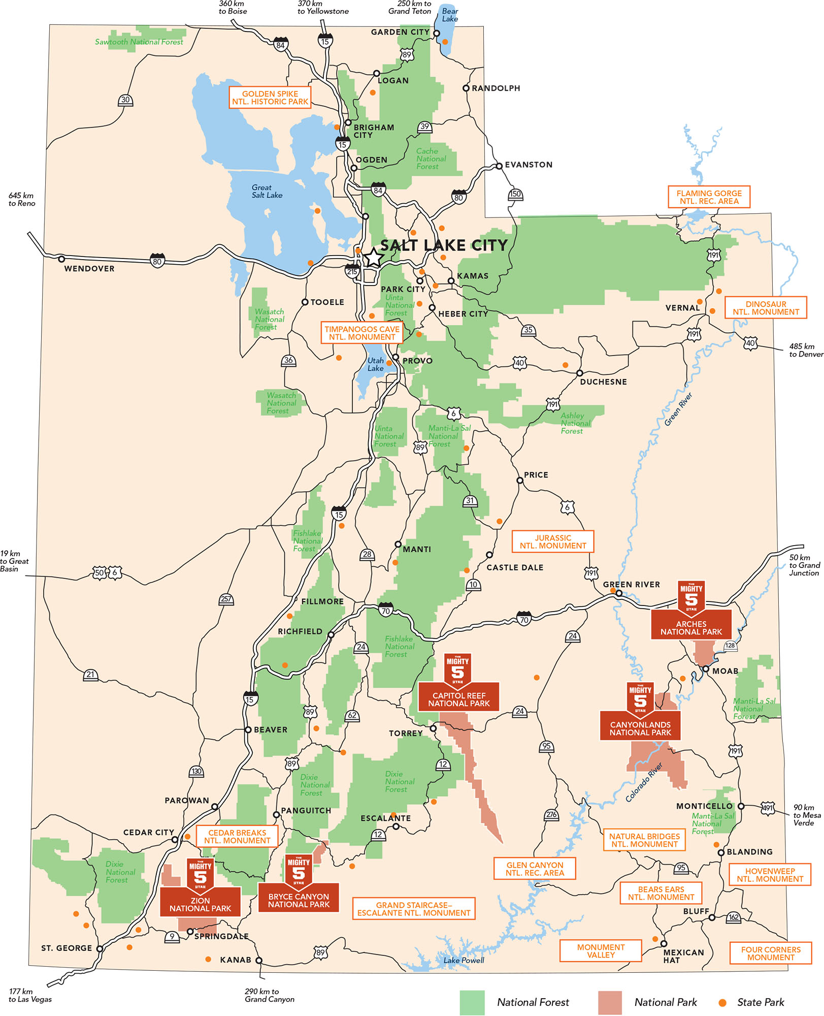
Map of Utah Highlights


Get a Free Utah Travel Guide
The official Utah Travel Guide will help you thoughtfully navigate from Utah's northern mountains and lakes to its southern red rock country.
More Travel Resources
-

Auto Rentals & Shuttles
Plan your trip in and around Utah with a list of transportation and recreational vehicle rentals. Find cars, RVs, ATVs, premium vehicles and snowmobiles.
-
Utah Driving Laws
Find out about Utah Driving Laws including driver license requirements, speed limits, seat belt laws, helmet use and more from the Utah Office of Tourism.
-
Road Conditions and Safety
Find Utah resources for the road conditions, weather, maps, public safety and more from the Utah Office of Tourism.