Hole-in-the-Rock Road to Peek-a-Boo and Spooky Gulch
Hole-in-the-Rock is a 62-mile drive one way, and follows the general route of of the pioneer Hole-in-the-Rock Expedition to search for a route across the river, what is now Lake Powell. Most of the road is in Grand Staircase-Escalante National Monument, however the last approximately 5 miles are within the boundaries of Glen Canyon National Recreation Area. Most visitors travel the 11 miles to Devil's Garden and 26 miles to the turnoff for Peek-a-Boo and Spooky Gulch. The BLM recommends high-clearance, two-wheel drive vehicles in dry weather. Should you decide to continue further, the road gets trickier. The last few miles within Glen Canyon are best traveled by foot, bicycle, or four-wheel drive vehicle. Numerous side roads leave Hole-in-the-Rock, but these are best traveled with a good knowledge of the region and four-wheel drive.

Devil's Garden area
Photo: Andrew Burr
Cottonwood Canyon Road to Cottonwood Narrows and Grosvenor Arch
The 47-mile Cottonwood Canyon Road connects the All-American Road Scenic Byway 12 in the north with Highway 89 in the south, passing by Kodachrome Basin State Park and numerous opportunities to get out and explore the monument that range from short hikes to backpacking excursions. Popular destinations include Cottonwood Narrows to the south and Grosvenor Arch toward the north. Many rugged stretches of Cottonwood Canyon can be impacted by storms, so travelers are advised to check at the monument's visitor centers for current conditions.

Scenic Byway 12
Burr Trail Scenic Backway from Boulder to Bullfrog, Lake Powell
What was originally developed as a cattle trail blazed by stockman John Atlantic Burr, the Burr Trail Scenic Backway is now one of the most picturesque drives in Utah. A paved and graded, gravel and dirt road, it extends from Boulder to Bullfrog Marina, passing through the Grand Staircase–Escalante National Monument, Capitol Reef National Park and Glen Canyon National Recreation Area. The Burr Trail also connects with the Notom Road in the Waterpocket Fold backcountry of Capitol Reef.
Numerous stops abound along the trail, including family-friendly excursions, scenic viewpoints and general meandering through juniper-laden desert. It's about 70 miles (more than 3 hours) from Boulder, Utah, to either the junction with S.R. 24 near Capitol Reef National Park or Bullfrog, a popular marina on Lake Powell.

Burr Trail Scenic Backway
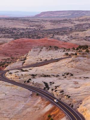
The All-American Road: Scenic Byway 12
This is 122.863 miles (to be exact) of pure driving bliss. Welcome to Utah’s Scenic Byway 12, a designated All-American Road.
Travel Tips
Visitors to the backways of Grand Staircase-Escalante National Monument should carry plenty of water (at least one gallon (4 liters) per person, per day) and be equipped to get themselves out of any difficulty they might encounter. Roads throughout the monument are not routinely patrolled by any agency. Summer temperatures can range over 100° F (38°C) and winters can drop well below freezing at night. Perhaps most importantly, sudden heavy rains, especially in summer months may make this road impassable — even for high-clearance, 4WD vehicles.
See more responsible travel tips.