Weaving Through Granite Mazes in the Mineral Mountains of Beaver County
Ramble through the Mineral Mountains, one of Utah’s most magnificent but least known natural wonders, offering superb hikes through a rugged granite wonderland of cliffs, domes and valleys. Backcountry trails beckon with the chance to discover precious gemstones, climbing routes and airy summits with expansive views across Beaver County — also known as Ramblers — in southwestern Utah.

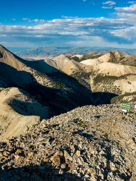
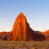
The secluded and rugged Beaver County is known as Ramblers, where four distinct mountain ranges rise above the Great Basin desert. At 9,580-feet, Granite Peak sits at the top of one of these ranges: the Mineral Mountains. This hike to Granite Peak is best suited for hardy hikers. It’s a brutish trip up the peak’s north flank, but those who make it are rewarded with an impressive summit overlook of sharp ridges clad in dark forests and studded with cliffs and spires gleaming white in the sun.
Outdoor enthusiasts can take their pick of such unforgettable adventures in the Mineral Mountains, which tower west of the town of Beaver and form one of Ramblers’ most spectacular — but least known — natural wonders (Read: “Ramble On: An Insider's Guide to Beaver County”). The rugged wonderland of domes, buttresses, pinnacles and castles below Granite Peak is an adventure playground with cliffs that beckon rock climbers, a network of old mining roads for off-road driving and superb backcountry trails coveted by savvy hikers. Near the Great Basin National Heritage Area is a thrilling region that doesn’t get the attention it deserves, which is great news for those who crave solitude, Western history and a unique outdoor experience.
Precious Gems and Minerals
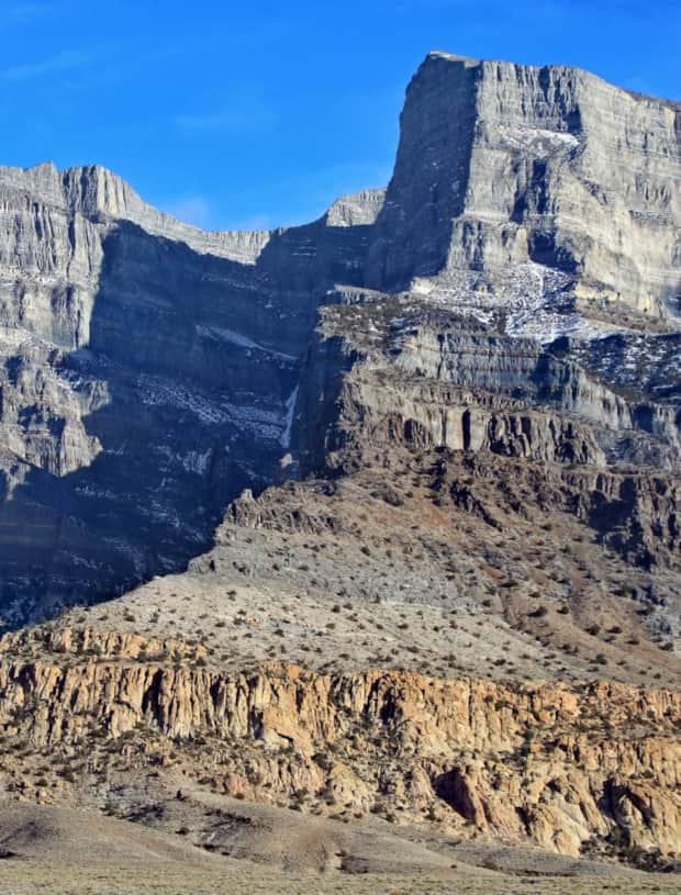
The Mineral Mountains are the largest exposed mass of solidified molten rock in Utah. A renowned rockhounding area, the range is also one of the richest in minerals, with collectors often finding amazing gemstones in the region. Area mines yield spectacular chunks of smoky quartz, opal, pyrite, gold, silver, obsidian and blue beryl — one of the world’s most prized gems. The famed purple opal site on the range’s western flank gives up astounding specimens with vibrant colors and patterns. Meanwhile, museum-quality specimens of azurite and malachite speckle old mine dumps in the southern part of the range.
Adventure Hiking in the Minerals
Designated hiking trails are rare in the Minerals’ rocky wilderness. Instead, modern-day explorers follow old wagon tracks still visible from the 19th-century mining boom as well as ancient paths once used by native inhabitants. Summiting Granite Peak and other noteworthy mountains requires careful navigation, cross-country hiking and scrambling over rock outcrops. The rewards are plentiful — sublime views of Ramblers’ landscape, excellent hiking and often, no one else on the trails. But, outdoor enthusiasts need to be prepared with the proper gear (and honest about their abilities) before embarking on the ambitious hikes in this region. Off-trail hikers, especially, need to be skilled with a map and compass or a GPS unit and carry the Ten Essentials, including emergency shelter, extra clothes and plenty of water in their packs.
Exploring the Rock Corral
The Rock Corral, a BLM recreation area on the western side of the range, offers dramatic scenery, primitive campsites, a picnic area at the road’s end and unmarked trails up shallow valleys, below granite domes and across sagebrush flats. An easy, 1.6-mile loop hike starts just before the picnic area at the end of Rock Corral Road. The narrow trail descends a valley to a trickling creek before bending west below a granite slab. Follow the creek to a rough road and climb out of the shallow valley to the access road.
"The Mineral Mountains are the largest exposed mass of solidified molten rock in Utah."

Another recommended hike heads south on a dirt track to a group of soaring white domes. Park by the only dome along the entrance road and walk one-tenth of a mile east on the road to the track that heads right. Follow the sandy 4x4 road south for 0.7 miles across a sloping plain to the smooth domes. Several paths explore the area, passing Plasma and Chromosome Domes. Meanwhile, sure-footed hikers can opt to scramble onto bare rock ridges on the Harvest Dome, the farthest east formation, for stunning views across the Corral.
Hidden Lake on Soldier Pass
An excellent one-mile, round-trip hike starts on the top of 7,408-foot Soldier Pass in the southern Mineral Mountains. Approach the pass from the west on a dirt road and park on the north side of the pass. A good trail makes a couple of wide switchbacks down a scrubby hillside and then skirts beneath an obvious granite dome creased with water streaks. The trail climbs through sparse piñon pine and juniper trees to tiny Granite Peak Reservoir, a gorgeous tarn tucked into a narrow rock canyon on the dome’s north side. It’s a quiet refuge of tall grass, birds, and glassy water mirroring sky and granite.
Hike up South Twin Flat Mountain
South Twin Flat Mountain is exactly that: a flat-topped peak overlooking the Right Fork of Ranch Canyon. A fine hike begins at a trailhead in the canyon on the west flank of the Minerals. Following an old 4x4 road, the trail spirals 1.2 miles around the mountain to its 7,951-foot summit, offering up vistas of the hazy San Francisco Mountains to the west and, to the south, Granite Peak and its neighbor, sharp Milford Needle.
After a quick break at the summit, shoulder your pack and head back down. For more adventure, take a right below the switchbacks and contour south along another old miner’s track into a section called the Park, a broad expanse flanked by tall pines and soaring rock fins.
Scrambling up Bearskin Mountain
Bearskin Mountain, believed to be named for a bearskin left to dry on bushes by an early Piute hunter, lords over the lonely northern end of the Mineral Mountains. The rounded, 9,099-foot summit is reached by a 1.6-mile hike on a 4x4 road to a saddle and then a short scramble up a barren ridge. At the top, expect solitude, silence and forever views across Utah’s vast basin and range province. Return to the saddle below and hike west up Little Bearskin Mountain for extra credit. The trailhead lies at the end of Bearskin Flat Road. Another good 1.6-mile hike starts from the same trailhead and heads west on an abandoned road to a broad ridge. Follow the open ridge west to the pointed summit of 8,307-foot Bailey Mountain, a rarely climbed peak that towers above Big Cedar Cove.
Climbing the Range High Point
The toughest but most rewarding hike in the Mineral Mountains is the steep two-mile ascent of 9,580-foot Granite Peak up the Right Fork of Ranch Canyon. Guarded by cliffs and sawtoothed ridges, Granite isn’t an easy peak to climb with brushy slopes, a faint trail and route-finding dilemmas. Start at the same trailhead as South Twin Flat Mountain and hike south up a narrow canyon to a wooded basin. Scramble up granite slabs and around abrupt cliffs on the peak’s northeast face to the lofty summit and the range high point. Bring trekking poles and microspikes for your boots if snow lingers on the upper face. For an extra shot of adrenaline, bring rock climbing gear and edge up Milford Needle, an airy spire on the north ridge reachable only by those with technical climbing skills.
No matter what type of exploring you like to do, there’s something to be found in the Minerals. With just a little preparation, you can delve into this scenic Ramblers section of the state and enjoy an unforgettable outdoor experience.
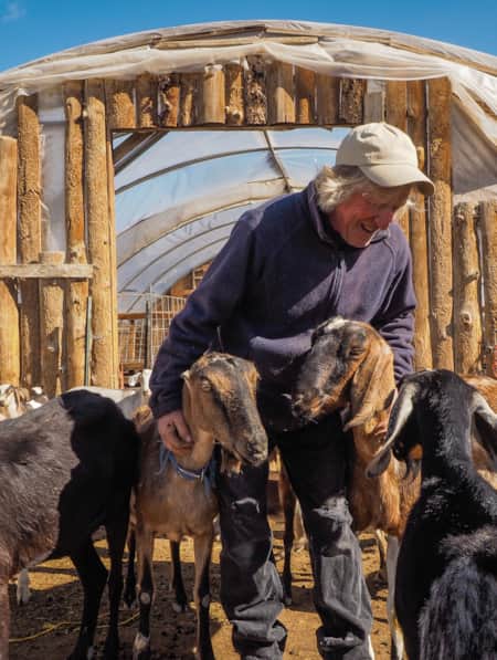
Learn more about rockhounding in Beaver County by visiting RamblersUtah.com/Rockhounding.
Grand Adventure in the Great Basin
In this five-day itinerary you won’t find many crowds. But take your time and you’ll find this desert geography isn’t so empty after all.
Highlights
- Territorial Statehouse State Park Museum
- Pahvant Valley Heritage Trail
- Topaz Incarceration Camp and Museum
- Sinbad Road / Hermit Cabin
- Great Basin National Park
- Cove Fort
Discover More
-

Utah’s Unexpected Pit Stops
Here are 11 mini-adventures to check off your list next time you’re road-tripping through Utah.
-
How to Day Hike Three Different Sections of the Scenic 23-Mile Skyline Trail
As a long day hike or multi-day excursion, this remote trail offers superb hiking, gorgeous scenery and, if you’re lucky, the chance to observe a herd of mountain goats.
-
An Insider's Guide to Hiking in the Tushars
One of Utah’s best-kept hiking secrets, the Tushar Mountains deliver sun-dappled trails, wildflower-sprinkled meadows, shaggy mountain goats and forever views from rocky summits. Check out these six choice Tushar trails and make plans to discover Utah’s third-highest mountain range.
-
How to Summit Three 12,000-footers in the Tushar Mountains
One of the least known and wildest mountain ranges in Utah, the Tushars is best explored by foot to fully capture the engulfing silence, distant vistas and glimpses of wildlife this alpine world has to offer.
-
Ramble On: An Insider's Guide to Beaver County
Ramblers, also known as Beaver County, is an outdoor playground. From winter to summer, check out the top 10 things to see and do in Ramblers.