The Ride
The Upper Colorado Scenic Byway — now part of the Dinosaur Diamond National Scenic Byway through Utah and Colorado — is best ridden as an out-and-back from Moab, where it’s known to locals as “the River Road.” There’s no lodging or amenities at the ride’s northern terminus in Dewey or Cisco, but starting in Moab gives you a variety of options. Riding this way will also give you the gentle climbs (a net total of just under 150 feet of elevation gain) first so you can enjoy the downhill trend on the way back into town.
The ride isn’t challenging in terms of elevation gain, but hot, dry weather are considerations for the warmer months. While the views are enough to draw attention away from the road, the road surface is well-maintained so you don’t need to worry too much about keeping your eyes glued to the road to avoid potholes and bumps.
Still, this tour isn’t for the faint of heart — the narrow shoulder is often just a foot or two away from precipitous drop-offs into the Colorado, and there’s potential for rockfall from the cliffs between Moab and the ghost town of Dewey.
The best riding (and the most killer views) are found in the 30 miles between the junction with U.S. 191 near Moab and the historic Dewey Bridge. If you are looking for a challenge, head all the way out to Cisco (the full 44 miles) where the road meets I-70 and gives you a view of the Book Cliffs. This nearly triples the ride’s elevation gain, and there’s little shade in the ecological transition between canyon country and high plains.
Pro Tips
Regardless of how long you choose to ride, it’s important to note that there are no services between Moab and Dewey, so you should plan to bring plenty of water and snacks for this section.
This route is best done in the spring and fall, when temperatures are most comfortable in the high desert, and it’s best to get an early start to avoid sharing the narrow road with too many vehicles.
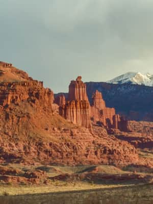
Cyclists looking to make a longer trip out of the Upper Colorado Scenic Byway route can plan to spend the night at any number of BLM-managed campgrounds along the way. Dewey Bridge Campground, has seven first-come, first-serve sites at $15/night, and the nearby Fisher Towers Campground (also $15/night) has spectacular views of the towers and nearby Castle Valley. Looking for comfier accommodations? Try Red Cliffs Lodge, whose riverside suites (and winery) are just steps from the Colorado — be sure to check out its movie museum.
A Madman’s Dream: The First Ascent of Fisher Towers
Explore the geological wonders of Fisher Towers and relive the "madman's dream" that led to the historic first ascent of its iconic Titan.
