Getting to Capitol Reef National Park
Capitol Reef National Park is located in south-central Utah. The park can be reached from I-70 via S.R. 24. From Salt Lake City International Airport, the trip takes about 3.5 hours. A road trip from southwestern Utah to St. George takes about 3.5 hours. Upon arrival at Capitol Reef, fill up on knowledge and know-how at the visitor center, nature center, store and museum.
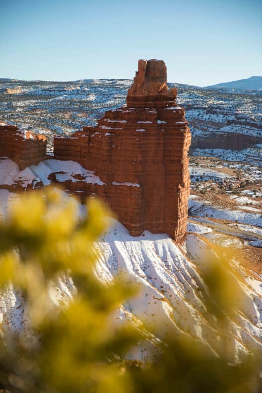
Chimney Rock
Photo: Andrew Burr
Geography and Geology
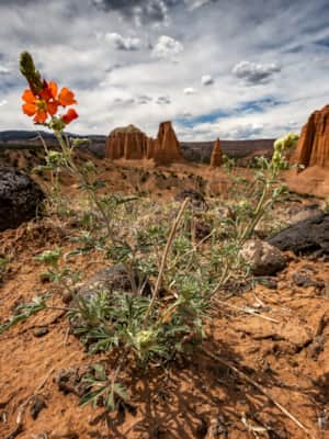
The park preserves the 100-mile Waterpocket Fold, a mammoth buckling of the earth’s surface (“waterpocket” refers to the potholes that dot the sandstone and fill with rainwater).
How Capitol Reef Got Its Name
The park’s name combines the popular term for an uplifted landmass, “reef,” with a visual resemblance of the park’s many white Navajo Sandstone domes to that of the nation’s Capitol Building.
Waterpocket Fold
Actually, the Waterpocket Fold was created relatively recently, at about the same time and by the same forces as the entire Colorado Plateau. A mere 65 million years ago (give or take a few millennia), when the uplift of the Colorado Plateau began, rock strata here were bent into a huge broken fold. Wind and water gradually eroded the ancient fold into the landforms and canyon systems we see today.
Sandstone Layers
Sandstone dominates Capitol Reef National Park. Each rock layer tells a story about different environments that spread across ancient lands. Here are the stone remnants of winding Permian-age rivers, mudflats and swamps of the Triassic, the sandy deserts of the Jurassic, and the landlocked seas of the Cretaceous Period. Most of these rock formations date from the Mesozoic Era, the age of dinosaurs, from 230 to 65 million years ago. The dominant formations are Wingate and Navajo sandstones, which respectively form steep cliffs and rounded domes.

Discover Torrey: Your Capitol Reef Basecamp
Travelers headed to Capitol Reef National Park often don’t know that they’re missing a hidden gem of a town — Torrey, Utah. This small town boasts way more than meets the eye and is your perfect basecamp for a Capitol Reef adventure.
Highlights
- Capitol Reef National Park
- Scenic Byway 12
- Stargazing
- Hunt & Gather Restaurant
- Sulphur Creek Trail
Hiking in Capitol Reef: 12 Ways to Travel Safe in the Desert
Many beginning hikers and newcomers to Utah are awed — indeed, perplexed — by the prospects of hiking the “desert.” Actually, the desert is a diverse country of deep canyons, shady, often lush river bottoms, high plateaus, bizarre rock formations and rich archaeological history. Hiking here inspires superlatives. Conditions can be harsh, but the desert does not have to be an inhospitable place to travel. Follow the general advice below and you can have a pleasant, safe and enjoyable trip.

1. Before you come, get a general idea of the kind of hiking adventures you are planning to do. Call the appropriate park management agency or a person familiar with the hike, or stop in at a visitor center and discuss your hiking plans with a ranger.
2. Also get a report on alerts and road conditions leading to the trailhead.
3. Avoid midsummer Capitol Reef hikes. In most cases spring and fall hikes are preferable.
4. You must carry all water with you at all times. Generally, one gallon per day per person is required.
5. Do not drink untreated water.
6. For those wanting to filter their own water, be aware that some river water may be too silty to filter. Carrying a collapsible plastic container is helpful because it permits the water to settle out while you are making camp.
7. Prepare for the sun. Use an extremely good sunscreen. A cap with a visor is also recommended. When hiking along rivers, legs can be particularly susceptible to reflected sun’s rays.
8. Deer flies can be bothersome in some areas. A good brand of insect repellent helps to solve the problem.
9. Watch the weather carefully. Flash flooding can be very dangerous. When hiking long distances in deep canyons, be sure to get a reliable long-term forecast. Remember that it does not have to be raining where you are hiking for danger to exist. A storm miles up the canyon can mean trouble.
10. Canyon hiking does not require the heavy boots necessary elsewhere. In fact, they become a burden when hiking long distances through water. Light canvas boots or old running shoes are recommended.
11. When river crossings are required, line your pack with heavy-duty plastic bags. Seal the bags well, and the pack will float across. Some hikers bring along an inflatable air mattress to use for ferrying packs.
12. Above all, prepare for your trip and use common sense.

Stay on Trail: Follow Cairns and Blazes
If you feel like you took a wrong turn, don't worry. Watch for indicators that you are indeed on the right route. These might include rock cairns, blazes (typically six-inch swaths of paint on trees and rocks), downfall cut with saws, paths cleared through thick timber and trees with the branches whacked off on one side.
Leave No Trace: Avoid Fines and Imprisonment
While hiking in almost any part of Utah, it is common to find archaeological sites and artifacts — dwellings, pottery, arrowheads, grinding stones and woven sandals. Unfortunately, artifacts are becoming less common, dwellings are crumbling under the weight of hikers scrambling over them, and petroglyphs and pictographs are being crowded by the likes of JIM LOVES SUE. Two federal laws, the Antiquities Act of 1906 and the Archaeological Resources Protection Act of 1979, forbid the removal or destruction of archaeological resources on Utah’s federal lands. The Utah State Antiquities Act, enacted in 1973, provides similar protection on state lands. Seemingly innocent actions can contribute to irreparable damage. Ancient painted pigments can be altered by the oil from fingerprints. Sitting or climbing on rock walls can turn culturally priceless structures into rubble. Walking across middens, the ancient trash heaps below structures, can damage sites and ruin an attraction for everyone. Admire art panels from a distance and never touch them. When approaching a cultural site, avoid walking on soft soils to reduce the chance of erosion. Stay out of the ancient sites. Report any vandalism to the nearest federal or state resource office. In some cases, rewards are offered.

Serenity Found in Torrey and Capitol Reef’s Cathedral Valley District
Taking Southern Utah’s remote, less-traveled path in Capitol Reef's Cathedral Valley District to nurture your body, mind and spirit.
