
Coyote Buttes South
What You’ll Remember: Red Rock Teepees and Solitude
Coyote Buttes is for anyone who has ever read an Edward Abbey book and pined to experience nature in its pure, unadulterated form. The landscape is also for anyone who doesn’t mind hiking without a proper hiking trail and letting their sense of exploration guide them. Explorers will take away memories of the glowing piles of red rock teepees at sunset, the lack of human noise or humans in general, and wandering about freely wherever you’d like and letting the time fly by.
What Makes it Great: Cottonwood Cove, Paw Hole
Getting a permit for The Wave in North Coyote Bluffs can be challenging. But don’t worry; Coyote Buttes South is a great alternative. Coyote Buttes South is remote and offers access to delicate features. Striped slick rock, painted over time by iron oxide, provides a fantastic array of reds, oranges, and yellows to feast your eyes upon. Walk among thin fins, arches, and the area’s iconic teepees.
Note that there are no established trails. Some well-worn paths have been made by hikers choosing the same route over time, but you are free to roam as you please—and it is encouraged to do so. A Coyote Buttes South permit provides access to exploration in two areas. The first is the scenic Cottonwood Cove, which brings you to the Cottonwood Teepees and other attractions just a .5-mile drive to the west. This area also has several free-standing wind-sculpted erosional statues, including “Turtle Rock,” “The Frog,” and “Dali Rock.”
The second area, Paw Hole, is, as mentioned, the spot to go if you only have time for one of the two areas. The colorful formations here sit on a ridge west of House Rock Valley. Because of the north-south ridge line, you can capture amazing light in your photographs at sunrise or sunset. Upon entering the trailhead, you’ll see the large red rock piles and teepees. You can go through the large corral directly through the teepees, but you will eventually have to cross through barbed wire to get to the west side (if you are trying to get pictures at sunset, you will want to be to the west of the formations with the sun at your back). Keep hiking anywhere you please, around and on the rocks. You will see some of the best views and features no more than two miles in and plenty more as you continue hiking.
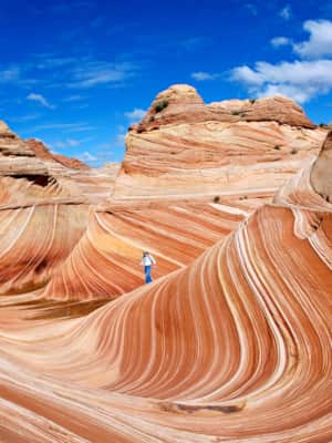
Coyote Buttes North (The Wave) Permit and Camping Information
As the name implies, the Coyote Buttes North permit area requires a permit for entry. A visit to this section of the Paria Canyon-Vermilion Cliffs Wilderness will require some planning to secure your spot– an advanced reservation lottery is available four calendar months before your visit. If you’re lucky enough to secure an advanced permit, you can plan your visit for any month. A daily permit lottery is also available, and you can access the area two days after the lottery.
While the Coyote Buttes Wilderness area prohibits overnight camping, nearby campgrounds and RV sites can accommodate those who want to spend a few nights under the stars. BLM Campgrounds, like the White House Campground, offer individual campsites on a first-come, first-served basis.
What's Nearby
-
Kanab
Kanab, Utah is classic American West, surrounded by towering Navajo sandstone cliffs and vistas of sagebrush. Kanab's self-proclaimed title, "Little Hollywood," is fitting for its many abandoned film sets.
-
Horseshoe Bend
Horseshoe Bend in Arizona is one of the most photographed natural wonders in the Southwest, and a great day trip from your base camp in Kanab, Utah.
-
Antelope Canyon
Want to visit the awesome Antelope Canyon? Utah offers all kinds of adventurous day trips for visitors — start planning your getaway today.
-
Glen Canyon and Lake Powell
Glen Canyon National Recreation Area offers more than 1.2 million acres of unparalleled opportunities for land- and water-based recreation.
