Ride Overview
Start: Arches National Park Visitor Center. Park here and get on your bicycle. Note that there is a $10 entrance fee for motor vehicles. There is a $5 entrance fee for bicycles, so an alternative is to ride to the park from Moab, about 5 miles to the south, along U.S. 191. Start from Swanny City Park (400 North 100 West).
Length: 46.4 miles (out-and-back, including two out-and-back side roads).
Terrain: Rolling; the ride begins with a steady climb on switchbacks, followed by a number of shorter climbs and descents. Minimum and maximum elevations: 4,097 to 5,173 feet.
Traffic and hazards: There were 780,000 visitors to Arches National Park in 2005. There is no park shuttle bus, so nearly all of the visitors drive the park roads. Be cognizant of the steady traffic volumes, especially during peak seasons. share the road signs are posted.
Bicycle Shops: Chile Pepper: 702 South Main Street, Moab; (435) 259-4688 or (888) 677-4688; www .chilebikes.com.
Moab Cyclery: 391 South Main Street, Moab; (435) 259-7423 or (800) 559-1978; www .moabcyclery.com.
Maps: Arches, Arches National Park, Utah, National Park Service, U.S. Department of the Interior. Distributed at the park’s visitor center.
Southern Utah, AAA Sectional Series, American Automobile Association. A detailed map of Arches National Park is included.
DeLorme: Utah Atlas & Gazetteer: Pages 46–47 D4 on page 46.
Benchmark: Utah Road & Recreation Atlas: Pages 70–71 F6 on page 70.
Getting there: From Moab, drive 5 miles north on U.S. 191 to the Arches National Park entrance, located on the right. The park is 28 miles south of I-70, on US 191.
Miles and Directions
0.0 Start at the Arches National Park Visitor Center. Exit the parking area and turn right. Begin climb. (Alternatively, start at Swanny City Park at 400 North 100 West in Moab. Head west on 400 North; turn right onto 500 West. Stop at Main Street (U.S. 191) and turn left. Head north across the Colorado River — narrow shoulders — and continue northward to Arches National Park.)
1.9 Crest of climb.
3.7 Courthouse Towers on the right. Also nearby, on the right, are The Organ and the Tower of Babel.
4.5 Cross Courthouse Wash and begin climb; note “petrified dunes” on the right.
8.8 Road levels.
9.0 Balanced Rock is on the right.
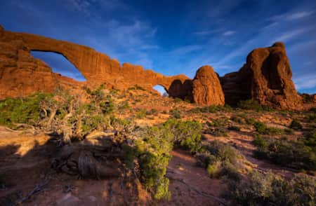
9.2 Turn right to head toward The Windows. Ham Rock is less than 1 mile in, on the right.
11.7 Enter The Windows parking area; watch for backing vehicles. Continue through the lot and around the loop. You may catch a glimpse of the Parade of Elephants on the right.
14.3 Stop at Arches main road (no street sign); turn right.
15.5 Begin steep descent; panorama of Cache Valley to the right.
17.6 Turn right to head toward Delicate Arch.
18.9 Floodwater crossing.
19.0 Begin gradual climb, followed by a descent.
19.8 Keep right; enter Delicate Arch parking area.
20.0 Exit parking lot and return to Delicate Arch road.
20.9 Floodwater crossing.
21.5 Begin climb.
22.3 Stop at Arches main road; turn right and begin climb.
26.3 Crest of climb.
27.2 Skyline Arch on the right.
27.7 Stay right; enter Devils Garden (one-lane road).
28.1 Enter Devils Garden parking lot; continue through and watch for maneuvering vehicles.
28.3 Exit parking lot.
28.5 End Devils Garden loop; now back on Arches main road for the return trip to the visitor center.
29.9 Begin descent.
33.9 Base of descent; begin climb.
35.5 Crest of climb; road levels.
36.3 Begin climb to Balanced Rock.
37.0 Crest; begin descent. Descent gets steeper after 1.2 miles.
41.3 Cross Courthouse Wash and begin climb.
44.0 Crest of climb; begin winding descent, on switchbacks.
46.4 End of ride; return to visitor center.
Ride Description
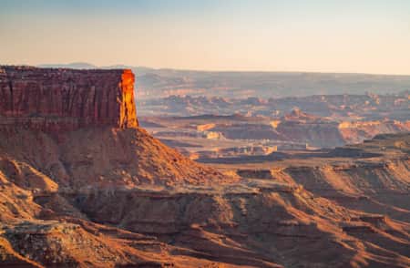
Arches National Park is one of two national parks in the Moab area (the other is Canyonlands) and one of six areas in the region administered by the National Park Service (NPS). Arches is one of the most visited parks in Utah. The layout of the park is extremely thoughtful of the tourist who wants to see the majestic scenery but who is not particularly into hiking, climbing, rappelling, or fording his or her way to a viewpoint. The roads through Arches practically provide drive-through scenery. At only a few selected spots is it necessary to get out of the car — or off the bicycle — and walk to see what’s out there. In that sense, bicycling through Arches National Park is fun. Among the bonuses of bicycling on NPS lands are the many signs that provide information about what you are seeing. Elevations within the park range from about 4,400 to 5,200 feet.
This region of Utah gets little snow, although temperatures can drop below freezing at night during the winter. Although the park can get crowded during the summer (May through September), share the road signs are posted to remind drivers of the presence of cyclists. Be particularly aware of carrying enough fluids during the summer, as well as skin protection. Vegetation in the park is scant because of the dry climate (only 10 to 11 inches of precipitation per year). Shrubs and grasslands are common, as well as cottonwood trees along washes. Piñon pines and juniper trees may be seen at higher elevations. Cryptobiotic crusts have formed on top of the soil in some places, enabling the growth of specially adapted plant communities. Wildlife — mostly nocturnal — includes antelope, ground squirrels, bobcats, collared lizards, coyotes, gray foxes, kangaroo rats, mule deer, porcupines, rattlesnakes, and ringtail cats. Sorry — no roadrunners for the coyotes to chase.
Turn right to exit the Arches National Park Visitor Center and begin a 2-mile climb, via switchbacks. At the top of the switchbacks, enjoy the panorama of the La Sal Mountains, which are to the southeast. From here, you may be challenged to keep your eyes on the road, because Arches is a smorgasbord of eye candy. Various counts estimate that there are from 1,500 to 2,000 arches within the compact 116-squaremile park. (Arches are sandstone formations that have been hollowed out through the erosive action of wind and water.) In addition to arches, there are numerous other rock formations, along with varied, tantalizing landscapes. Most of the prominent formations have names that incite the imagination. At mile 2.7 (from the park entrance), you enter the eerie landscape of “petrified dunes” — red-hued sandstone, buckled and shifted over an unstable bed of salt after exposure to wind, water, freezing, and thawing. The road is primarily downhill here.
At mile 3.7, you are surrounded by five outstanding rock formations, including The Organ, Courthouse Towers, and, a little farther up, the Tower of Babel on the right; Three Gossips and Sheep Rock are on the left. Continue descending to the crossing of Courthouse Wash, then begin to climb. Petrified dunes are on the right; rock pinnacles and The Great Wall are on the left. Balanced Rock is on the right at mile 9.0. Turn right at mile 9.2 (from the park entrance) to head toward The Windows (there are no street signs within the park). The road continues for 2.5 miles before emptying into the parking area for The Windows. Presuming that you are not planning to dismount, continue through the parking lot, around the loop, and return to the road for the return trip. Although you may not see any “Windows,” you will see Ham Rock on the right on the way in, and the Parade of Elephants on the right on the way out. The Garden of Eden and Double Arch are on the right on the way out.
At the main road, turn right and continue toward the interior of the park. You have now covered 14.3 miles. The road descends, getting steeper at mile 15.5. Turn right at mile 17.6 to head toward Delicate Arch. This is Arches’ most photographed arch. If you do not dismount and walk the trail at the end of the 2.2-mile road, however, you will not see the arch. On the way to the Delicate Arch parking area, you will pass by Wolfe Ranch, where the Wolfe family lived from 1888 to 1910, attending to their cattle. Just beyond the ranch, on the way to Delicate Arch, is a floodwater crossing.
Return to the main road and turn right to continue into the park. You have now covered 22.3 miles. The road climbs; the arches and rock formations disappear for a while as you pass through a desert scrub landscape. Off to the right is the Fiery Furnace, an intricate maze of deep slots and narrow canyons. Spires appear on the right at mile 25.0; the road crests at mile 26.3. Skyline Arch is on the right at mile 27.2. One-half mile later, you enter Devils Garden, a truly extraterrestrial landscape.
If you want to see the staggering collection of arches in this area, you must get off the bicycle and hike. Otherwise, continue through the parking area, around the loop, and return to the main road.
The return trip allows a different perspective on the memorable sights seen on the outbound trip. You will not ride any of the spurs on the return. The return ride begins with a 4-mile descent, from miles 29.9 to 33.9, followed by a 1.6-mile climb. The road is level for 0.8 mile, then there is a 0.7-mile climb to Balanced Rock.
From here, descend for 4.3 miles to Courthouse Wash, followed by a 2.7-mile climb to Courthouse Towers on the left, Three Gossips on the right, and the other majestic rock formations aforementioned. Viewing these magnificent structures again is a reminder that some of Arches’ most breathtaking scenery is within just 3 miles of the entrance. Just beyond this area, begin to descend, on switchbacks, to the visitor center. Your inspired legs probably will not even feel as if they have just ridden 46.4 miles (especially if you remembered to bring enough fluids).
Ride description from Road Biking Utah (FalconGuides)
-

Arches National Park
Arches National Park contains more than 2,000 natural arches—the greatest concentration in the country. Find places to stay, itineraries, and weather for Arches, Moab and Canyonlands National Park.
-
Canyonlands National Park
Canyonlands is home to many different types of travel experiences, from sublime solitude in the more remote stretches of the park to moderate hikes through the Needles district to the opportunity to create your own version of one of the West's most photographed landforms, Mesa Arch.
-
Moab Hiking
Everybody knows that the famous national parks near Moab, Arches National Park and Canyonlands National Park, offer excellent hiking opportunities. But Moab also offers lots of excellent trails with the same spectacular scenery — without the crowds or entrance fees.