Newspaper Rock & Indian Creek Corridor
What Makes it Great
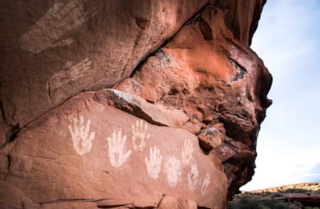
As one of the largest collections of petroglyphs in the country, Utah's Newspaper Rock State Historic Monument is like a living museum. However, thankfully, you don’t have to peer at the pristine rock art through glass at this site.
Peoples from the Fremont, Ute, and Anasazi Native American tribes etched their markings here. It’s surmised that the perennial natural spring attracted ancients to this distinct area. There are over 650 rock art designs and include animals, human figures, and various symbols, some thought to be religious in nature. These petroglyphs were produced by pecking through the black desert varnish found on the rock to the lighter rock beneath.
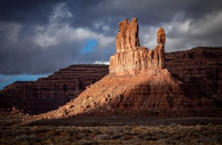
After enjoying the rock art, get back in the car and check out the rest of the 19-mile Indian Creek Scenic Byway. Driving westward, the sharp sandstone cliff walls are mesmerizing. Approximately 12 miles from the red rock canyon of Indian Creek, you’ll venture into the Needles District of Canyonlands National Park.
What You’ll Remember
Standing at the base of the 200-square-foot rock and trying to decipher what the ancients were trying to communicate; craning your neck to count all of the artwork; sketching and replicating some of the petroglyphs in your own notepad; losing count when you try to see who can count the most antelope; driving the awe-inspiring byway and looking at all of the massive, perfectly-red Wingate sandstone cliffs.
GPS Coordinates, Parking and Regulations
GPS Coordinates:
(37.988325, -109.518501)
There are no fees or permits required to visit Newspaper Rock or to drive the Indian Creek Scenic Byway through Indian Creek National Monument. There are fees to enter Canyonlands National Park. Just across the highway from the petroglyphs there is a picnic area and campground, which is free and is first-come, first-serve.
The area is open year-round, and the best times to visit are March through late-May and September through October. Feel free to bring your dog, but most places require furry friends to remain on-leash.
Travel Advisory
Visitors traveling to Bears Ears National Monument should note there are very limited travel services. Much of the land in the area is rugged, wild and remote, and requires greater preparation, fitness and respect. Please review our travel advisory.
What's Nearby
-

Bears Ears National Monument
A pair of towering buttes stand against beautiful scenery. The twin buttes are so distinctive that in each of the native languages of the region their name is the same: Hoon'Naqvut, Shash Jáa, Kwiyagatu Nukavachi, Ansh An Lashokdiwe, or in English: Bears Ears.
-
Valley of the Gods
Perhaps one of the most intriguing names of all of the destinations in San Juan County is the Valley of the Gods. This special area attracts individuals looking for idyllic sandstone structures.
-
Monticello
The southeastern Utah town of Monticello lies on the sheltered eastern slope of the Abajo Mountains, overlooking a maze of sandstone canyons and plateaus.