Pont Hickman et Navajo Knobs
Le point de départ des sentiers menant à Hickman Bridge et Navajo Knobs offre trois options de randonnée, selon le temps et l'énergie dont vous disposez. La marche aller-retour de 2,9 km jusqu'à Hickman Bridge prend environ 1 h 30, la randonnée aller-retour de 7,4 km jusqu'au belvédère de Rim Overlook (sur le sentier de Navajo Knobs) prend entre trois et quatre heures, et la randonnée aller-retour de 15,1 km jusqu'à Navajo Knobs prend entre six et huit heures. Le sentier menant à ces trois destinations commence le long de la rivière Fremont, puis descend dans un lit de rivière asséché offrant une vue imprenable sur le Capitol Dome, qui a donné son nom au parc en raison de sa ressemblance avec le Capitole des États-Unis à Washington D.C.
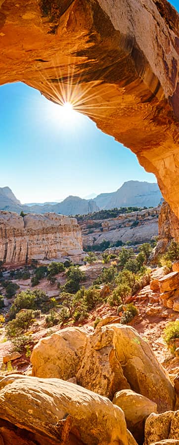
Après 300 mètres, vous atteindrez le carrefour de Hickman Bridge et Navajo Knobs. Pour admirer Hickman Bridge, une arche naturelle en grès, prenez à gauche. Le sentier grimpe progressivement de 120 mètres à travers un paysage caractérisé par de hautes parois rocheuses couleur sable, des genévriers, des peupliers et d'anciennes dunes de sable. Vous pourrez observer en chemin quelques vestiges du peuple Fremont, comme les restes d'une maison semi-enterrée et d'un grenier. Le sentier arrive ensuite à une bifurcation ; vous pouvez alors emprunter l'une ou l'autre direction pour passer sous le pont. Sculpté par l'eau, Hickman Bridge culmine à 38 mètres de hauteur et mesure 40 mètres de long.
Les sentiers menant au belvédère de Rim Overlook et à Navajo Knobs offrent des vues panoramiques extraordinaires sur le sud-est du Colorado, notamment sur les crêtes rocheuses ondulées et inclinées du Waterpocket Fold, les monts Henry et la vallée de la rivière Fremont. Ferme Gifford et des vergers de Fruita nichés au cœur de ces montagnes. Ces randonnées sont exigeantes en raison du dénivelé, mais les panoramas magnifiques qui les entourent en valent largement la peine. Quelle que soit la saison, emportez beaucoup d'eau, surtout en été.
Le sentier menant au belvédère grimpe régulièrement de 338 mètres, serpentant entre les canyons. Il débouche ensuite sur le rebord de la falaise, offrant un panorama vertigineux sur la vallée en contrebas, à 305 mètres de hauteur.
Si le cœur vous en dit, vous pouvez poursuivre la randonnée sur 3,9 km et 150 mètres de dénivelé positif pour atteindre les Navajo Knobs ; l’aventure vaut largement l’effort supplémentaire. Le sentier longe le bord du canyon sur environ 1,6 km (parfois très près, alors faites attention où vous mettez les pieds !), offrant des vues sur « Le Château », une immense formation de grès en terrasses. Il bifurque ensuite vers l’ouest, contourne une autre paroi rocheuse et, enfin, arrive aux Navajo Knobs. Comparés à certains autres paysages rencontrés le long du parcours, ces buttes ne semblent pas spectaculaires au premier abord, mais ne vous y trompez pas : c’est un spectacle à ne pas manquer. Après une courte ascension jusqu’au sommet culminant à 2 127 mètres, vous serez soudainement saisi par un panorama à 360 degrés absolument incroyable. Le désert et les montagnes s'étendent à perte de vue sous vos yeux. Un spectacle inoubliable.
Coordonnées GPS : 38.288780, -111.227650
