
Bald Mountain Summit
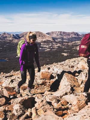
This hike begins at the well-marked Bald Mountain trailhead, located at the base of Bald Mountain. You start climbing immediately and will soon find yourself traversing a series of switchbacks on the western slope. The view is great all the way, and it somehow manages to improve with every step. Near the summit, the trail follows a thin ridge with steep drops off either side. There’s really no danger if you stick with the trail, but a person with acrophobia might feel uncomfortable. Then take a natural rock stairway to what feels like the top of the world.
Take your time on this hike. It is steep. Allow about four hours for a round-trip, which should give you plenty of time at the top to appreciate the views in every direction. Heed a couple of safety reminders on this hike: (1) Stay off Bald Mountain when lightning is possible. (2) Don’t get too close to the cliff edges on the east side — they can break away. Follow these rules and your name won’t be added to Bald Mountain’s casualty list. OK, now don’t let us scare you away. This hike is time well spent.
The Hike
Overview: Bald Mountain — the best time investment you can make in the High Uintas. Just 2.5 miles of steep hiking puts you atop this well-known peak, where you’ll have a bird’s-eye view of four of Utah’s major watersheds.
Start: Bald Mountain trailhead
Distance: 5.0 miles out and back
Destination elevation: 11,943 feet
Approximate hiking time: 3.5 hours
Difficulty: Moderate — steady climbing
Usage: Heavy
Nearest town: Kamas, Utah
Drainage: Duchesne River
Maps: USGS Mirror Lake; USDA Forest Service High Uintas Wilderness; Trails Illustrated High Uinta Wilderness
Trail contacts: Uinta-Wasatch-Cache National Forest, Heber-Kamas Ranger District
Finding the trailhead: From Kamas, take the Mirror Lake Highway (Highway 150) 30 miles to Bald Mountain overlook. About 0.5 mile north of the overlook is the left turn to Bald Mountain. Bald Mountain has space for twenty-five cars and offers picnic tables and toilets. No water is available. Bald Mountain trailhead is heavily used by hikers making the 2.5-mile trek to the top of Bald Mountain, where you can peer into four major drainages.
Introduction to Hiking Utah's High Uintas
Standing at 11,943 feet above sea level, Bald Mountain is one of the highest peaks in the western Uinta Mountains. Happily, the Mirror Lake Scenic Byway gets you within a couple 1,500 feet of the summit.
