The trail includes several named sections, starting with Burro Pass, then Hazzard County, Kokopelli, then Upper Porcupine Singletrack, Lower Porcupine Singletrack, the famed Porcupine Rim Trail, and finally the Colorado River. There are several access points along the way that shorten the overall riding route, so if you aren’t ready for the whole enchilada, you can still enjoy the best of what this trail has to offer.
Depending on the time of year you ride, come prepared with a waterproof jacket over your short-sleeved jersey, and maybe even full gloves. Make sure to pack plenty of water and snacks, as well as the basics — your shades, repair kit, and a trail map. This is an epic 33-mile ride, and you’ll need all of your gear!
Riding the Trail
Most folks hire one of the several guide and shuttle services in town to travel to the top of Geyser Pass in the mountains above Moab. Back when this bike ride was first conceived, it included riding the trail to the top of Geyser Pass from Moab, then descending what we now consider the Whole Enchilada trail. But that adds 30 miles of uphill biking (and possibly hiking) to an already-grueling ride, so modern-day softies skip that bit and opt for a shuttle up the mountain.
Pile into the shuttle and sit tight for the long and windy drive up to the trailhead, which sits at an altitude of about 10,400 feet above sea level. Trips should start in the morning, so plan on very chilly temps at the top. Your initial climb to the 11,000-foot saddle of Burro Pass will wake you up better than any coffee around.
Descending from Burro Pass, anticipation is palpable. You won’t be able to hold in the whooping and hollering as you get moving though the dense forest full of steep switchbacks that eventually open into awesome aspen groves. The next trail section, known as Hazard County, is fast and flowy. This part is filled with kickers, small gap jumps, and banked corners for those who prefer adding a little extra spice to their enchilada experience.
After Hazard, you enter a stretch of the dusty, rolling Kokopelli road trail and then the Upper and Lower Porcupine Singletrack sections. Here, the trail steps it up a notch in terms of technical difficulty, incorporating ledges, drops and slick rock sections, that you just can’t believe your tires are sticking to, all while riding along the edge of a sizable cliff. It may be safer to walk some of these more dangerous sections rather than riding them, although one rider hailing from England recommended, “just have a healthy appreciation of curse words and you’ll be fine.”
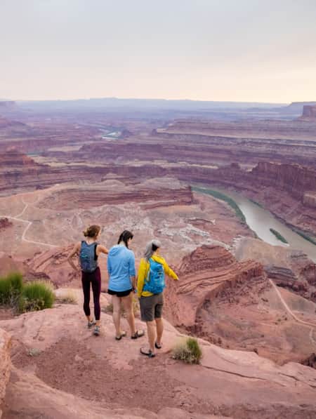
Once you make it through this part, you’ll find yourself at the official Porcupine Rim section, where the trail clings to the side of a sizeable sandstone cliff. Ride carefully, channel your inner mountain goat, and bask in the airy views surrounding you. The view into Castle Valley, before the Porcupine Rim Trail descent begins in earnest, makes for an unforgettable lunch spot. The final stretch of Porcupine Rim is the pinnacle of the ride, especially when the winding Colorado River comes into view as you make your way toward the canyon floor.
Some of the shuttle services include an action photographer waiting to capture the last moments of your ride on the final roller. The look on your face is one you’ll be able to relive the ride through for years to come — gratitude, relief, exhaustion, satisfaction, and the overwhelming need for a cold beer. Make plans to come ride one of the top mountain bike trails on Earth!
GPS Coordinates: 38.488231, -109.232448
-

Moab
Moab is surrounded by a sea of buckled, twisted and worn sandstone sculpted by millennia of sun, wind and rain
-
Moab Hiking
Everybody knows that the famous national parks near Moab, Arches National Park and Canyonlands National Park, offer excellent hiking opportunities. But Moab also offers lots of excellent trails with the same spectacular scenery — without the crowds or entrance fees.
-
White Rim Trail
For a scenic, multi-day Canyonlands mountain biking tour, head for the White Rim Trail! Learn more and plan your expedition today.