About 8,000 years ago, another group — perhaps descendants from the Paleo-Indians — developed a distinct culture revolving around hunting and gathering. Archaeologists call this the Desert period archaic culture.
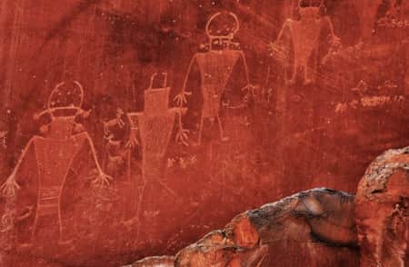
The Fremont culture followed them. The Fremont followed the season of the bighorn sheep, elk, and deer, all of which inhabited what is now Dinosaur National Monument. Many wonder, Why did the Fremont create the numerous pictographs and petroglyphs found in and around Dinosaur? No one knows for sure, but many possibilities exist, leaving room for much speculation.
Some of the petroglyphs in Dinosaur are aligned in such a way that the sun touches them most directly on the day of a solstice or equinox. Perhaps these drawings were used to signify the time to plant crops. Petroglyphs may also be an expression of what the designer would want to see. For instance, consider the couple holding hands at McKee Spring. Was this the day of their marriage?
Whatever the case, Dinosaur preserves an incredible array of petroglyphs. The following offers routes to some of the more easily located examples. And please remember that touching the panels or making rubbings corrodes the images and is an illegal activity.
McKee Spring
McKee Spring is one of the most accessible and impressive of all the panels in Dinosaur National Monument — not to be missed! Take Brush Creek Road about 5 miles. Turn right on Island Park Road and proceed for 12 miles, reentering Dinosaur National Monument. McKee Spring is located about 3 miles beyond the park boundary along Island Park Road.
Echo Park
Petroglyphs abound in and around the Echo Park area. Some are located on a rock ledge above the campground. The Pool Creek petroglyphs are located on the left about 0.5 mile before arriving at Echo Park Campground. Other petroglyphs are located directly across the Green River from the raft-launch site.
To reach Echo Park, start at Headquarters Visitor Center (Colorado) on Harpers Corner Road. Travel 25.9 miles on Harpers Corner Road, then turn right at the sign for Echo Park Road. Go 9 miles. At the first T-junction, take the left-hand turn to Echo Park (there is a sign) for 4 more miles.
Tour of the Tilted Rocks
To get to Tilted Rocks, use the western (Utah) entrance at the dinosaur quarry. In general, drive from the entrance station along the main road for about 5 miles, passing on your left the turnoff to the launch site and, 1 mile later, the turnoff to Green River Campground. Continue for about another mile, crossing the bridge over the Green River. From the bridge, proceed about 2 miles to a pullout. Here you will see a multitude of images. As is always the case, the most interesting drawings are reached with some effort. Follow the trail up the rather steep incline for about 200 yards until you reach the panel. Here you’ll see a number of drawings of huge lizards.
Jones Hole Trail
This panel provides one of the most impressive groupings of pictographs in the monument. To reach it from the Quarry entrance station, follow the road out of the monument to Brush Creek Road. Take Brush Creek Road northeast to Diamond Mountain Road, which turns into Jones Hole Road, for about 20 miles to the Jones Hole National Fish Hatchery. At the hatchery, follow the signs to the trailhead. From here, proceed down the trail for about 2 miles to the sign pointing to the Deluge Shelter. Turn right. A short hike will take you to the panel of pictographs. These pictographs are among the monument’s most impressive. Look at the various forms, and once again you’ll see what may be a shaman and bighorn sheep and a number of concentric circles.
Mantle Cave
Mantle Cave can be accessed while floating the Yampa River. On the river, float about 200 yards past Mantle Ranch. The owners post their Internet address on a sign along the bank. Just downstream from the sign, beach your boat. Follow the well-delineated though unmarked trail through the brush, then uphill for about 0.5 mile to the cave’s entrance.
Mantle Cave offers some panels, but more impressive is the cave’s huge structure, which once contained small granaries for food storage. Inside the cave, a trail takes you to several granaries, once used to safeguard corn. Look inside and you may see one small remaining ear. Once there were hundreds.
Other Sites
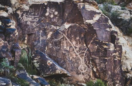
Hundreds, possibly more than 1,000, other sites dot the monument, but you’ll have to explore the backcountry and float the rivers to see them. Because of past vandalism, the park has elected not to delineate the location of all panels or the considerable number of very impressive dwelling sites. We are following their lead. In a way this policy makes the discovery of a new panel more exciting, for you can believe with much justification that you are one of the few to have seen what you are seeing.
-

Capitol Reef Petroglyphs
Capitol Reef is home to towering sandstone structures and impressive canyons, but it also holds many ancient petroglyphs, which are engraved etchings into rock walls.
-
Cycling the Parowan Gap Loop
Parowan Gap: A 50-Mile Adventure Brimming With History.
-
Historical Sites in Utah
Explore Utah's fascinating past with our guide to historical sites and hidden gems. Uncover pioneer and indigenous stories at these Utah heritage hot spots.